


Massive 1,000-Km Cloud Formation Signals Rain Over North India
The unusual cloud build-up highlights strong moisture incursion from the Mediterranean region, raising the likelihood of severe weather events. Authorities have issued advisories urging residents to stay alert and monitor updates as the disturbance intensifies.
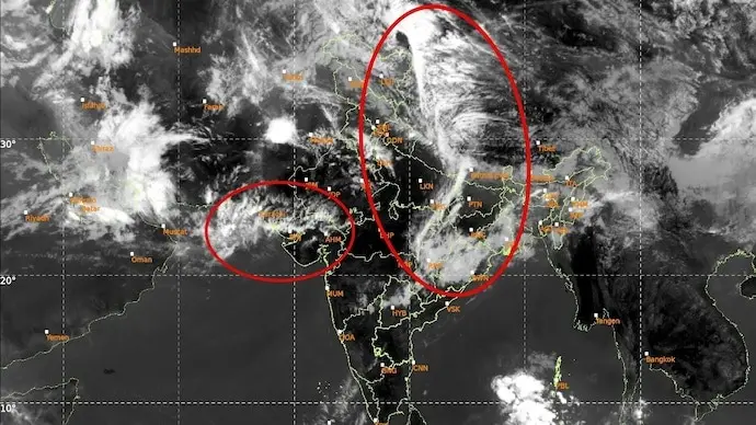
Weather System Details
The IMD confirmed that two active western disturbances are impacting northwest India, with peak intensity expected on April 3–4 and again on April 7. The cloud band is multi-layered, indicating heavy moisture accumulation and potential for intense rainfall.
Impact On Regions
Northern states including Jammu and Kashmir, Himachal Pradesh, Punjab, Haryana, and Rajasthan are likely to experience rain, thunderstorms, and hail. Urban areas may face traffic disruptions, while agricultural regions could see both benefits and risks depending on rainfall intensity.
Preparedness Measures
Authorities have advised residents to avoid unnecessary travel during peak weather activity, secure outdoor structures, and stay updated through IMD alerts. Farmers are encouraged to take protective measures for standing crops, especially in Punjab and Haryana.
Weather Highlights
- Satellite captures 1,000-km-long cloud band over India and Pakistan
- Linked to active western disturbance from the Mediterranean
- Peak intensity expected on April 3–4 and April 7
- Rain, thunderstorms, hail, and gusty winds forecast for northern states
- Advisories issued for residents and farmers to prepare for disruptions
Sources: India Today, MSN, India Meteorological Department
Stay Ahead – Explore Now! Women Voters Poised to Swing Delhi Assembly Elections 2025

Latest Updates

Bajaj Housing Finance Reports Q4 Gross Disbursemen...
53 minutes ago
SOBHA Reports Robust Q4 Sales At INR 20.39 Billion...
56 minutes ago


Top Stories
Bajaj Housing Finance Reports Q4 Gross Disbursemen...
53 minutes ago